One unique feature of Cartographica is the ability to create a click-able web map from geospatial data. By using the layers of the map to create a web-compatible image file and then using the data in the data table, it can make each click-able area correspond to a link on the site or on another site. It can also provide roll-over text.
Creating a web map
Choose > .
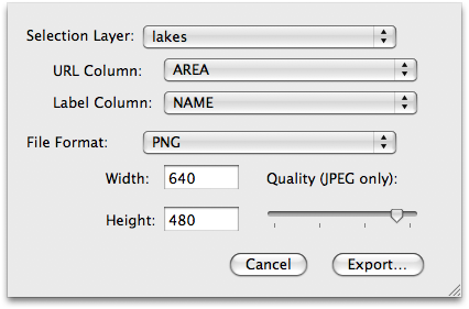
The Export Web Map sheet appears.
You will be prompted to provide the following information:
Selection Layer - The layer which is used to bound the selections. This must be a polygon layer.
URL Column - The column that contains the URL (if any) that should be the target of the link.
Label Column - The column that contains the label to be used for the target of the link.
File Format - The type of image file (JPEG, GIF, TIFF, or PNG) to create for the map.
Width and Height - The dimensions of the map to be produced.
Quality (JPEG Only) slider - If you have chosen JPEG as the file format export format, the Quality slider allows you to choose the level of quality for the output image. A lower quality also guarantees a smaller (byte-wise) image.
Once you have set all of the information options, click .
Two files will be created for you: an image file and an HTML file in UTF-8. The HTML file contains the geometric information and the links which serve as the basis for a web page that will contain the map.